Back Fredericksburg and Spotsylvania National Military Park CEB Fredericksburg Confederate Cemetery German Fredericksburg and Spotsylvania National Military Park French
| Fredericksburg and Spotsylvania National Military Park | |
|---|---|
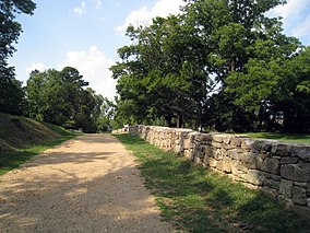
 The stone wall along Sunken Road, in Fredericksburg | |
| Location | Spotsylvania County and Fredericksburg, Virginia, United States |
| Nearest city | Fredericksburg, Virginia |
| Coordinates | 38°17′35″N 77°28′09″W / 38.29306°N 77.46917°W |
| Area | 8,405 acres (34.01 km2)[1] |
| Established | February 14, 1927[2] |
| Visitors | 534,636 (in 2005) |
| Governing body | National Park Service |
| Website | Fredericksburg & Spotsylvania National Military Park |
Fredericksburg and Spotsylvania County Battlefields Memorial National Military Park | |
| Area | 4,601.1 acres (1,862 ha) |
| NRHP reference No. | 66000046[3] |
| VLR No. | 111-0147 |
| Significant dates | |
| Added to NRHP | October 15, 1966 |
| Designated VLR | January 16, 1973[4] |
Fredericksburg and Spotsylvania National Military Park is a unit of the National Park Service in Fredericksburg, Virginia, and elsewhere in Spotsylvania County, commemorating four major battles in the American Civil War: Fredericksburg, Chancellorsville, The Wilderness, and Spotsylvania.
- ^ "Listing of acreage – December 31, 2020" (XLSX). Land Resource Division, National Park Service. Retrieved 2021-08-15. (National Park Service Acreage Reports)
- ^ "Park Anniversaries". Retrieved 13 August 2021.
- ^ "National Register Information System". National Register of Historic Places. National Park Service. March 13, 2009.
- ^ "Virginia Landmarks Register". Virginia Department of Historic Resources. Retrieved 19 March 2013.
© MMXXIII Rich X Search. We shall prevail. All rights reserved. Rich X Search

